An Abbreviated History of
Pittsylvania County, Virginia
Chapter Two: Discovery and Natural Conditions
By Maud Carter Clement,
Chatham, Virginia, ca. 1952.
Pittsylvania lies in South-Midland Virginia, bordering on the North Carolina line. Its length from north to south is forty miles, from east to west twenty-eight miles, giving a total area of approximately 1,012 square miles, the largest of Virginia’s one hundred counties.
Pittsylvania lies wholly in a Piedmont plateau, having a rolling surface broken by many small mountain ridges. The first range of hills westward from the coast, of sufficient size to dignify with the name of mountain, is a gentle ridge traversing the south eastern part of the county, called the White Oak Mountain. A score of miles farther on rise Turkey Cock Mountain in the West and Smith Mountain in the Northwest, both rugged and steep; while across the northern part of the county stretch the ridges of Jasper, Farmer and Bushy Mountains. In between these low ranges and rolling hills are fertile valleys watered by many streams.
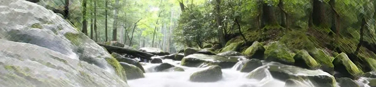
Pittsylvania is well drained by three water systems; Dan River in the southern part, Banister River in the central part, while Staunton River forms the northern boundary of the county.
Lederer, the Indian trader, in 1670, described the country near the Virginia and North Carolina line as having rich soil “as I judge by the growth of the trees, yet where it is inhabited by the Indians it lies open in plains.”
Beverly, who wrote an early history of Virginia (printed in London, 1705), said that the explorers of midland Virginia found many large level plains, three or four miles wide, on which were large numbers of deer, elk, buffalo and turkeys “so gentle that they had no fear at the appearance of man.” These large open spaces were always said to be level and were no doubt the farm lands of the Indians, who found that the clearing of a hillside caused it to wash away, and therefore chose for their corn fields the rich, level “low grounds.” For this reason the early explorers found the streams to be sparkling clear filled with fish.
Another quality of the landscape mentioned by the early explorers was the openness of the woods, large trees standing some distance apart, with grass and flowers growing underneath, giving a park-like appearance.
The Indian traders Botts and Fallam, who visited our Indians in 1671, recorded in their journal that they saw here “trees vastly big as I believed the world affords,” and that the woods are “as fragrant as a garden” with wild flowers almost all the year. They also noted the meadows of hundreds of acres without any trees at all which yield “reeds and grass of an incredible height.”
Louis Michel, of Switzerland, made a trip through Virginia in 1702 and wrote: “The forests are convenient to ride and hunt in. The trees are far apart with no undergrowth on the ground, so that one can ride anywhere on horses. The game is easily discovered because of the openness of the forest. The hunting of the Indian helps to clear the forest and pasture.”
The openness of the forests was brought about by the Indian custom of firing the woods at regular intervals, the larger trees being able to withstand the burnings. This was done to make living conditions easier for the red man, both in hunting and in his travels through the forests.
The openness of Pittsylvania’s woods is a tradition handed down by the elder people of the country. We are told that when the first settlers came they found this to be a land of plenty, for not only did the woods abound in game of every kind for their table, but growing through the woods was a wild vetch that provided food for the stock all winter. The horses after having been worked through the day, were belled at night and turned into the woods to graze, and kept in good condition on no other food. An early traveller, J. D. F. Smythe, in writing of this section bears this out when he says, “The inhabitants give their cattle and stock salt once a week to gentle them, for in this mild climate where there is no occasion to provide food for them in winter, they would go entirely wild, for they live in the woods.”
Colonel Byrd mentions seeing vetch growing wild on his trip to Eden, but feared it would be destroyed by the hogs. Vetch was found only where the forests were open and the sunlight came in, being proof of the openness of the woods.
In a petition for a road to Banister Bridge in 1752, it is stated that “the back inhabitants are obliged to pick out a way through the woods for the passage of their wagons and other carriages.” It would be impossible to drive a wagon through Pittsylvania woods today, so thick is the undergrowth.
Colonel William Byrd, of Westover, was a member of the commission appointed in 1728 to survey the dividing line between Virginia and North Carolina, and in his account of the trip he recorded many interesting things of that section which later became Pittsylvania. (Byrd’s “The Dividing Line” can be found in the State Library.) He wrote: “On October 10th we crossed the south branch of Roanoke River for the first time and it Dan. It was about two hundred yards wide where we forded it and when we came to the west side we found it lined with a forest of tall canes.” They found the river perfectly clear and “exceedingly beautiful.”
Two miles farther on they came to a creek which they named Cane from the quantity that fringed the banks. Byrd described the canes as being thick as a man’s wrist and keeping green all winter. It is strange that this growth which nature provided to protect the banks of the streams should have disappeared from the county. Each time Dan River was crossed Colonel Byrd remarked upon the beauty of the stream, climbing near-by hills to enjoy the view. You will note from your map that the state line crosses Dan River five times within the limits of Pittsylvania.
Byrd noted that the wild geese were beginning to arrive from the north; on their first coming they were lean, but soon fattened on the grass of the river banks.
The surveying party brought with them their bread and engaged a Sapony Indian from Fort Christiana, named Bearskin, to keep them supplied with game. While encamped on Cascade Creek, which they named for its waterfalls, ” the Indian killed a fat buck, them men brought in four bears and a brace of wild turkeys, so that this was truly a land of plenty.”
Upon reaching the mountains (now Patrick County), the party turned back having run the line 241 miles.
On their return they halted at the bend of the Dan for “there was no passing the angle of the river without halting a moment to entertain our eyes with that Charming Prospect.” Colonel Byrd marked the richness of the land and soil “the fertility of the soil throws out such a quantity of winter grass that horses and cattle might keep themselves in heart all the cold season without the keep of any fodder. Nor have the low grounds only this advantage but likewise the higher ground.”
After passing the last ford of the Dan, the dividing point between Halifax and Pittsylvania, the men grieved sorely for the game left behind.
Five years later Colonel Byrd again visited this section when he came with a party of friends in 1733 to view the purchase of 20,000 acres which he had made south of Pittsylvania and called the Land of Eden. Six miles west of the forks of the Dan and Staunton Rivers they came to the house of Peter Mitchell, who was “the highest inhabitant up” (fartherest [farthest] west). Then for six miles they rode “through charming low grounds to a large stream which we agreed to call Banister River.” A member of the party was John Banister. Upon this trip Byrd and his party had the good luck to kill a young buffalo; upon which they made a great feast. The abundance of game once found in Pittsylvania is shown in the Surveyor’s Book of Land Grants, the earliest record in the Court House, dating from 1737, four years after Colonel Byrd’s last visit. Since the county was one vast woodland, it became necessary for the surveyors to mention the natural conditions in describing the metes and bounds. In so doing they left a description of the county before the white man made his home here.
There were many buffalo roaming the hills, leaving their well-marked trails to feeding and watering places. An old frontiersman of this section, John Redd, said of buffalo paths, “In the neighborhood of all licks with which I have been acquainted there are roads of very ancient appearance which were made by the animals, and it is sometimes the case that the roads are located with a good deal of judgment in crossing hill or ridge.” No doubt many of these buffalo paths through the woods became the first roads of the settlers.
An early traveller through the county described licks as being on the banks of rivers, creeks and spring heads where the earth has a salt taste. “These licks are natural openings of a few acres in extent, without a vestige of a tree; but the ground is always covered with an abundance of excellent long grass. They are frequented by buffalo, elk and deer which daily resort to them to lick the earth or clay with their tongues.”
The surveyors mentioned buffalo paths, buffalo beds in Wynn’s Creek, buffalo rolls on Jonakin Creek, and a buffalo camp on Mill Creek. Buffalo licks were numerous and named on various streams through the section. There were upper and lower licks on Sandy and Miry Creeks, and great licks on Wynn’s and Cane Creeks; others were mentioned on Whitethorn, Tomahawk, Chestnut, Allen and Pigg River. There is a ford on Banister River which is still called Buffalo Ford.
With the coming of settlers the buffalo retired westward across the mountains to a less resorted range.
The surveyors made mention of the bears found here, as for instance: “To John Nicholds four hundred acres beginning at a White Oak cut down for a bair.” “1754: To Robert Pusey four hundred acres on Otter Creek of Smith River, beginning at a forked poplar with a hole near the root made to take out a bear.”
So numerous were the bears that there was a place on Sandy River know as Bear Garden: “1745, To Richard Green two hundred acres on both side Sandy River, beginning at the lower end of Bear Garden.”
There were beaver dams and beaver ponds on Banister, Pigg and Stinking Rivers as well as many creeks. Fish dams, elk shoals, and wolves’ dens were named as pointers by the surveyors.
Turkey Cock Mountain was so called for the many flocks one seen there. We are glad that this noble bird is beginning to return to the county.
The Meadows are a peculiar formation of country extending through the eastern part of the county, many miles in length and are thought to be the bed of a prehistoric lake. They have always been a favorite feeding ground for grouse and as late as the beginning of the last century (1800) Indian arrow points could be gathered like gravel from the ground (Captain Isaac Coles). As late as 1840 deer were still feeding there.
In the original growth of our forests there were trees of tremendous size. In a land grant of 1748, to Isaac Cloud mention is made of a “hollow chestnut tree in which Cloud and Smith used to camp, on the grounds between a branch of Banister and Turkey Cock.” This tree stood near Callands, and was of great size to admit sleeping quarters for two men.
We are told (Michel) that the oak tree was the most numerous and largest of the forest trees. They produced such heavy crops of acorns that the early settlers’ hogs lived entirely in the woods. Michel wrote, “pigs are no care as they are always left in the woods. They find their food throughout the year.”
The forests also abounded in nut trees, the walnut, the hickory nut and the chestnut which yielded showers of their rich and nourishing fruits each autumn.
There is a small native tree, the pawpaw, which has the unusual quality of striking fire. This was known to the Indians whose method of using it was described by Byrd as follows: “They hold one of the dry sticks in each hand, and by rubbing them hard and quick together, rarify the Air in such a manner as to fetch Fire in Ten Minutes.” This fire was used in all their sacred ceremonies. The pawpaw is found growing along the streams and in the fall of the year bears fruit somewhat like a banana.
The natural conditions of the country are reflected in the naming of the streams. There are White Oak, Birch, Sycamore, Reedy, Cane and Whitethorn Creeks; for the wild game there are Bearskin, Turkey Cock, Panther, Buckskin and Elkhorn; the Indians gave us Tomahawk, Indian Field Branch and Shocko[e].
We have seen that traders from Eastern Virginia had found their way to the more western county as early as the middle of the seventeenth century (1650), and traded with the Indians for furs, the skin of the wild animals of the forest. At first these could be purchased for a string of beads or a yard of cloth; but later, seeing the advantage of the white man’s fire-arms and ammunition over his own bow and arrow, the Indian demanded these in payment.
Besides the great companies of traders, like Major Woods and Colonel Byrd, there was always the independent trader like John Lederer, who went alone among the tribes. When Colonel Byrd made his second trip to this section in 1733, he saw a giant beech tree on which had been cut: “J.H, H.H, B.B., lay here the 14th of May 1673.”n The initials read Joseph Hatcher, Harry Hatcher, Benjamin Bullington, three Indian traders who had camped under the tree sixty years before.
With the passing of the Indians and their trade there grew up a hardy race of white hunters who went into the forests with their own guns and secured the pelts for the fur market. They were the explorers of the wester country, often naming mountains and streams as they came to them; and they were the forerunners of the settlers, acting as guides through the forests which they well knew from their hunting.
When the hunting were as far distant as Kentucky and Tennessee the hunters remained on their trips for one or more years; and so were known as “long hunters.” Much courage and strength were required in long hunting but a rich profit was the return. We are told that an industrious hunter could build up a store of pelts that would sell for “16 or 1700 pounds,” a great sum of money for those days. (Haywoods’ Tennessee)
Among the first settlers of Brunswick’s western lands were many noted long hunters who explored Tennessee and Kentucky, hunting there for many years. Elisha Walden, the men of the Blevin family, the Skogg brothers — Charles, Richard and Henry, with others were hunting in the western country as early as 1761. When Henry Skogg’s camp was plundered by a Cherokee half breed, he carved on a tree “Fifteen hundred skins gone to ruination.”
There is a story of an early hunter who named one of Pittsylvania’s streams. We are told that he seated himself beside the stream to rest and refresh himself. The day was probably warm, for upon opening his pack he found that his venison (deer meat) was tainted. Throwing the meat into the water he named this beautiful small stream Stinking River; and so it is called today.
