- This topic has 2 voices and 11 replies.
-
AuthorPosts
-
December 22, 2005 at 8:24 am #1966
I thought that I would move this over here rather than taking over the “Tracking down the Green family” thread…
Originally posted by barryc
I am a Green from Greentown in Brunswick County VA. Greentown is an Indian community on still on the Saponi Reservation land. There are also Greens in the Haliwa-Saponi tribe. There is also a Greentown in Nash Co NC. I have also seen quite a few Greens in the Hawkeye community in the Southern part of NC as well as the Lumbee area.
Green seems to be a pretty common Indian name in VA and NC.
Barry
Is there any significance to the various towns named “Greentown”, or is it just pure coincidence?
According to Mapquest, there are 7 towns names “Greentown”. All of them being in the eastern half of the U.S. They are located in…
Brunswick Co., Virginia
Currituck Co., North Carolina
Marion Co., Tennessee
Pike Co., Pennsylvania
Jefferson Co., Ohio
Stark Co., Ohio
Howard Co., Indiana
The US Graphic Names Database also adds an 8th location in Fayette Co., West Virginia. Here are a few descriptions of some of them…
The Greentown that is in Howard County is about 5 to 10 miles from where I live. When my family 1st settled in Howard County in 1846 that is the area that they lived in, but Greentown wasn’t platted until 1848. County history says that this Greentown got its name from either (1) the town was named for a clearing of green grass that was in lush contrast to the area of wild wilderness that surrounded it, or (2) it was named by Chief Shocomo, who lived in the village of twenty to thirty cabins just one mile south of Greentown. We may not ever be certain of the precise origin of the name, but for whatever reason, it is a special name reminding us of our beautiful green and fertile land.
Henry Bailey was the first white settler, settling in present-day Jerome. He then moved to the Indian Village south of present-day Greentown at the invitation of Shocomo and Shoc-co-to-quaw. Bailey next laid claim to the present site of Greentown. He later sold the claim since he was never one to stay long in one place. In 1848, Jesse Osborn and Tarver Seagraves platted the town, thus, Indiana land became white man’s domain.
Per http://www.accessgenealogy.com/native/newjersey/
Delaware Indian Villages
Greentown, on the Black Fork of Mohican River near the boundary of Richland and Ashland Counties, Ohio.
http://www.heritagepursuit.com/Richland/RichlandChapXXII.htm
…Between Sections 1 and 2, Armstrong’s Creek, running southwest, was crossed. It was so named from Capt. Thomas Armstrong, an old Indian chief, who resided at Greentown, eight miles above. The Indian trail running north, and to the Gelloway settlement on the Waldhoning, is mentioned. The land of Hanover is noted its rough and poor, covered with stunted timber, much burnt on the northeast part of the township. Green Township was also surveyed by Gen. Hedges, in April, 1807. “In running the south and east boundary. Gen. Hedges seems to have Been much embarrassed,” says Dr. Hill, “over the variations in his compass. In order to test the accuracy of the survey, the lines were re-surveyed. He could not determine the cause of the variation.” Magnetic ores may have existed in the earth on the line and influenced the needle. On the south line of this township, the timber was much burnt; underbrush was plenty. On the west boundary, Mohican John’s Creek was crossed, and on the fourth mile to Muddy Fork of Mohican “John’s Creek, they crossed the stream and came to the Indian village of Greentown, which at that date contained fifty or sixty families. The village occupied rolling land. in section 18. A number of well-used trails led in various directions from the town. The surveyors drove a section post in a corn field, which they mention as being well cultivated. The village and graveyard were estimated to contain five or six acres. The Indians offered no resistance to the survey. In fact they hardly comprehended its significance. The land in this township, down the valley is regarded as prime, other portions poor. The varieties of white oak. burr oak, ash and other hard timber are noticed….
http://www.springtwp.com/history.html
Here is a description of one in Ohio…
There were a great number of Indians in Greentown, but they and the settlers got along quite well. Within a decade, all of the Indians left and the “noble red man” passed to reservations beyond the “Great Father of Waters”-the Mississippi.
Stacey
December 22, 2005 at 8:24 am #38146Noticing similar community name – Greensfork – with Saponi descendants in Indiana. Learning about the Blackfork Ohio community clued me in to the name. Think you are on to something here…. only took me a little over ten years to find this. 🙂
December 22, 2005 at 8:24 am #38171Hi Marc,
I found some history on Greens Fork, Indiana. It didn’t get that name until 1889. Before that, it known as Washington. Apparently, there were two Washington, Indiana’s in southern Indiana and it was causing confusion, so the town changed it to Greens Fork because of the the Greens Fork creek that runs by the town. The creek was named for a Delaware Indian named Johnny Green who lived along this creek.
http://www.waynet.org/community/greens_fork/greensforkhistory.htm
https://www.facebook.com/CTHPS/posts/509126995922921:0
Stacey
December 22, 2005 at 8:24 am #38173That history of Greens Fork talks about the town being platted by a Hatfield and an Elliott. Through DNA I have found cousins with these surnames/locations. The Elliott’s in my cousins’ lines come from the sa New Garden and Back Creek monthly meetings in NC as my ancestors. They established another Back Creek Monthly Meeting in Indiana. The Hatfield cousins also matches another cousin with Blackfoot oral history.
It seems the Quaker network was used to support people relocating from NC to IN. White people whose faith made it hard to live in a slave state. Historically free people of color who were becoming increasingly disenfranchised by racist laws. I’ve been doing research on the Quaker connections to communities of color in the old Northwest Territory. There are more connection there than the history books tell us about. The history is preserved more from family histories. Some towns in the Northwest Territory (OH, IN, MI, WI) were platted by mixed blood descendants specifically for their community. Communities with history of African and Indian descent that were intentionally mixed.
There are Green’s mixed in with these lines but I cannot tell who is who. There is a pattern of several people with the same name showing up. I first noticed it when Bill Childs helped us on our lines about ten years ago. It is in the Elliott’s too. It seems like it was to make people harder to trace. Harder to trace meant harder to enslave, harder to steal land from, but also harder for us to trace now.
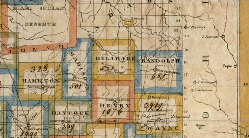
In this 1830s map Greens Fork is still Washington. You can see reservation lands were not far away. These frontier border county people had a relationship with the reservation communities. The Quakers had much to say about the injustice of Indian removal in OH and IN at this time. One of the land documents for my ancestors has language about the lands being formerly Miami lands hand-written in. This is also when the ‘Senecas of the Sandusky’ were in Ohio, a group who seem to have multiple Saponi ties. We are living proof of the connections between these communities. Even if many have forgotten their history.
 December 22, 2005 at 8:24 am #38174
The land that was the Miami Indian Reserve is where I live. 🙂 Some of my family lines started settling here in 1844, but my Jones line didn’t come here until the early 1900s. I think that is the main reason why my family was told that my Jones line was Miami Indian. I think my great-aunt said this just to appease the ones that were asking because the Miami were local to our area. Most of my cousins that stayed behind in Ohio were all told Cherokee. (I don’t believe that to be correct either because of the area of Virginia (VA/NC border) my Joneses were from and the other families that they lived near and married into, which is also how I came to the Saponi forum. Cherokee just seemed to be “safe” and most prevalent one to pass on.) The one cousin that was an exception to that said her family was told that we were from a tribe out west. I asked her if it was Blackfoot and she said she didn’t remember the name and said they didn’t put much stock in what they were told because it never made sense.
The Quaker connections are interesting to me, too. It appears as though my Jones family were tenant farmers and lived on land owned by Jonas Janney during the 1850 census in Greene Co, OH. Jonas Janney was a Quaker from Virginia and passed through Greene and Warren Counties in Ohio before settling in Madison County, Indiana.
I have quite a few Indiana Quaker lines in my tree (most were in the areas of Wayne, Rush, Henry, Hancock, Madison, & Delaware Counties), but none that are directly linked to my Joneses. I do have Elliotts in my tree (married into the Lindleys) that were from North Carolina to Wayne County, Indiana. After Wayne County, they came to Howard County, Indiana. I have a couple of Hatfield lines in my tree, but I don’t know if they are Quakers. One was in Fayette County, Ohio. The other was in Rush and Howard Counties in Indiana and married into my Cook and Stone lines.
The Indiana Historical Society put together some history of the early black (mixed) settlements in Indiana. There are links to each county’s settlements. The Wayne & Randolph Counties settlements (and others) specifically mention the Quakers.
http://www.indianahistory.org/our-collections/reference/early-black-settlements#.WB6q9fkrLIU
Who was your ancestor that patented land on Miami lands? When did they to come to Indiana? Have you seen the BLM website? Here is a map/history that our local library put together about the “New Purchase” in 1818: http://www.howardcountymemory.net/default.aspx?id=12794
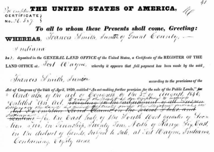
December 22, 2005 at 8:24 am #38181My ancestor who came to Indiana was Francis Smith 1781-1865. His genealogy is a brick wall, I don’t know his parents, and his name was most likely changed to Smith when he came from VA. He listed WV as his place of birth. It was his son Francis ‘Frank’ Smith Jr. 1821-1916 who had the land grant I mentioned. He married Elizabeth Kennedy (Canaday) 1826-1902. Not sure exactly when they came to Indiana but it was in the 1830s. They came from Clinton County Ohio. Frank Smith Jr is not my direct ancestor, his brother David B Smith is in my direct line.
Here is the land grant with the text referencing “the treaty from the Miami Indians of Indiana”
Who were your specific Elliott and Hatfield ancestors? Were they from Randolph NC?
The Cherokee ID I think sometimes comes from ancestors who submitted affidavits to Dawes or Guion Miller Rolls. It is assumed they were Cherokee because they applied to Cherokee Rolls, but in many cases they were not. There was just no other avenue open towards recognition from the government at that time. At least that’s how I see it.
December 22, 2005 at 8:24 am #38182The BLM website gives the details in a different way than the one on Ancestry. Here is a link to it:
If you haven’t used BLM website before, it has a neat little feature under the “Patent Details” tab, about half way down is a map of the United States. Just above that, is one line that says “Land Descriptions”. If you click the little box on the left side of that line, it will plot on the map the section where that the land patent is on a current map.
If you go to the “Related Documents” tab, it lists all the people that patented land in that particular section. (I’ve noticed my family usually bought land near each other.) I didn’t know if any of those names would help you out, but I noticed there was a Thrailkill on there and that was the cemetery that most of them were buried at, so they would have been neighbors.
According to a biography on “Frank” Smith, his paternal grandfather was Shorten Smith. It also said both of his grandfathers (Shorten Smith & David Jones) fought in the American Revolution. It said his wife’s parents were Andrew Kennedy and Sarah Scrugg or Seggs (it mentions both). The biography was in a book titled “Biographical Memoirs of Grant County, Indiana”. It was published in 1901. The part on “Frank” Smith is on pages 659-661. Here’s a link to it: https://dcms.lds.org/delivery/DeliveryManagerServlet?dps_pid=IE1898560&
The oldest Elliot that I have in my tree was Aaron Elliott (1792-1848). Not sure where he is from. He isn’t a direct ancestor. He was married to Mary “Polly” Lindley. The Lindleys were from Orange Co, NC. They also married into the Howells that were from Chatham Co, NC. These are the families of my 3GGrandfather’s first wife. They intermarried with my great-aunts & uncles, and cousins (all in Howard Co, IN) and also donated land for a cemetery where 15 of my greats-grandparents are buried in.
Not sure how the Hatfields in Fayette Co, OH are connected. I have a newspaper article from 1933 saying that Flora (Hatfield) and T.A. Curtis came to a Jones family reunion. They are one of the few listed that attended that I haven’t identified yet.
My direct Quaker lines that I know of that were in Randolph Co, NC are Millikan, Rush, Hammer, York, Raines, and Meeting. This would have been in the 1700s.
December 22, 2005 at 8:24 am #38183My mother has recently been looking at Shorten Smith as Francis’ father. I wasn’t sure at first but this is starting to add up. I wasn’t aware of that book. Thanks! 🙂 David Jones 1747-1790 is Massa Jones father – Francis Smith Sr’s wife. The Thrailkill’s are around my ancestors in Ohio and Indiana.
We also have Hammer’s in this line. Harriet Good 1812-1870 who married David B Smith was the g-grandaughter of Hannah Hammer 1720-
Through DNA I found a cousin with Elliott’s. In particular:
Rev Exum (Axum) Elliott Sr
1765–1841
BIRTH 10 APR 1765 • Perquimans, North Carolina
DEATH 8 OCT 1841 • West Grove Cem. N. of Centerville, Wayne, Indiana
son of Jacob Elliott 1740-1828 Randolph NC and Zilpha Davenport 1742-1765
I need to revisit the Shorten Smith info my mother has put together. This is a longstanding brickwall we have only started to make progress on lately.
December 22, 2005 at 8:24 am #38184Glad it helped. 🙂
Here’s what I have on my Hammer line…
Hannah Hammer (1785-aft1860) m’d John York
…Elisha Hammer (1756-1837) m’d Elizabeth Raines
……Abraham Hammer (1731-?) m’d Rachel Meeting
………Aaron Johannes “John” Hammer (ca1683-?) m’d Jane Unknown
Hannah, Elisha, and I believe Abraham were the ones that were in Randolph Co, NC. Before North Carolina, they were in Pennsylvania.
Hmm…The Elliott/Lindley marriage took place in Wayne Co, IN in 1814.
December 22, 2005 at 8:24 am #38186I looked, but I can’t tell if your Hammer’s are tied to mine or not as I have so little info on my side.
You seem to have a really good knowledge of maps. I’ve been doing some researching but having trouble placing a military district map. It’s an 1809 Ohio map I found in the ‘U.S., Indexed Early Land Ownership and Township Plats, 1785-1898’ collection. It’s Township No. X, District No. VI.
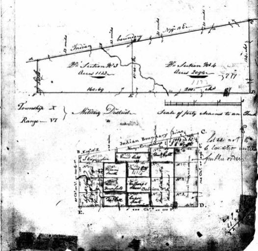
Francis Smith has a section on this map. I’m trying to tell if it could be my Francis Smith. My Francis Smith first shows up on the census in 1820 in Richland Twp, Clinton County, Ohio.
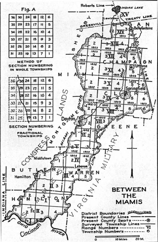 If I’m reading the top map right it is within this map – Range X, Township 6. Present day Clark County Ohio. And the ‘Indian Boundary Line’ in the to map is the ‘Ludow Line’ in the bottom map.
With this being the overall Virginia Military Tract (present-day Ohio)
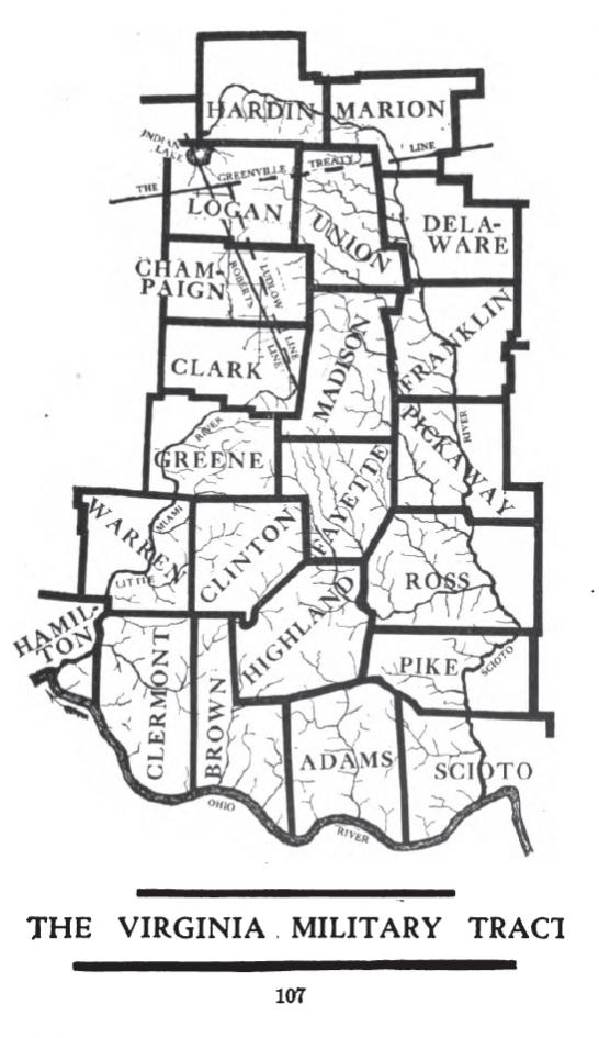
Can you tell for sure where the land in the top map is within the VA Military Tract?
December 22, 2005 at 8:24 am #38187The top map isn’t within the Virginia Military Tract. It is part of the 1797 “Army Lands” (aka the U.S. Military Survey). Here is a link to an 1804 map showing the “Army Lands”:
https://www.mapofus.org/_maps/atlas/1804-OH.html
That particular Francis Smith’s land is in present-day Holmes County. The patent is for “James Alexander assignee of Francis Smith, late a soldier in the Pennsylvania Line.” Here’s the patent:
If you click the “Related Documents” tab, you can see some of the other names included in your top map (Horsefield, Coll, Sheets, Hogg, etc), so we know we are in the right section.
This map shows the “Army Lands” with the present-day counties:
December 22, 2005 at 8:24 am #38211Found this article talking about the formation of Greens Fork Indiana:
http://www.usatoday.com/story/news/nation/2015/09/28/indiana-town-greens-fork-killer/72978202/
-
AuthorPosts


- You must be logged in to reply to this topic.

.png)