
- This topic has 14 voices and 60 replies.
-
AuthorPosts
-
March 29, 2004 at 10:32 pm #922
Becky and I had the great pleasure of hosting a meeting with Linda and a representative of the Upper Saura from Stokes Co this weekend. After sharing lunch at a local diner where almost everyone who entered was triracial, we guided them on a tour of the Flatt River basin.
If this works right, Linda is gonna put up the pictures and I will explain what they show. Bear with us until it is all done…. should be great for the archives as it seems about all of us have ancestors who passed through the Flatt River area.
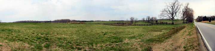
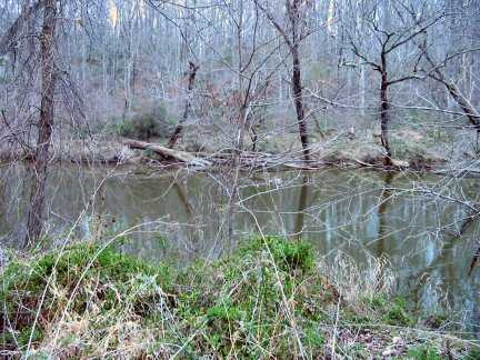
Panorama from Moore’s Mill Rd between Red Mtn Rd and US 501. Flatt River runs along the distant treeline the full length of panarama.
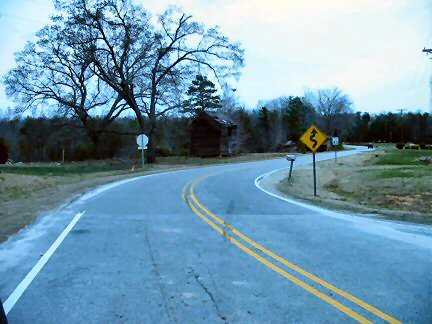
Looking down Moriah Rd in “Bass country”
“Bass Country” Red Mtn Rd at Moriah Rd
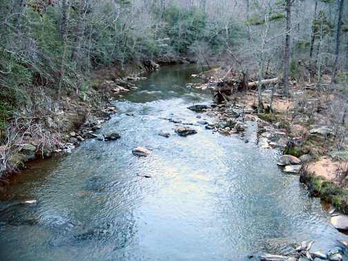
Looking at Flatt River from the Moore’s Mill Rd bridge

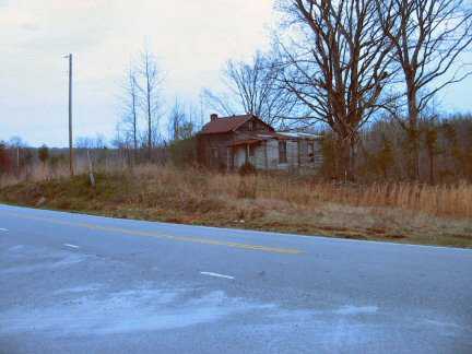
Moore’s Mill between Helena Moriah Rd and Red Mtn Rd….. the next 2 pictures were taken from this site.
Looking out to river from road……. btw, yes, this couple of miles does get underwater frequently….. if it’s been a lot of rain, don’t take Moore’s Mill Rd..LOL
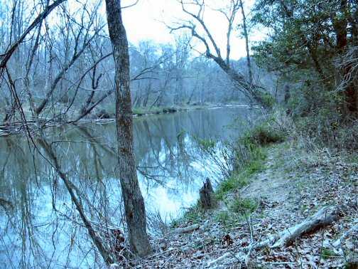
Looking downriver from the bank….
March 29, 2004 at 10:32 pm #9360Hello, this sounds like well deserved and needed addition, I look forward to this update and hope that it will explain where the event took place and perhaps a map to the area.
all the best Tom
March 29, 2004 at 10:32 pm #9365The pics turned out great!! This is a good representation of the area here where we live. I really enjoyed our day together and meeting you, Linda. And Ken, you did a great job on the details of the area for the folks.
March 29, 2004 at 10:32 pm #9368Folks I shared the URL with Jack Goins and here is his reply. I too would like to find those first minutes.
Hi Brenda I’m glad you are getting better. You sure have done a great job researching your Collins family and I know they are proud of you. I remember the first time you called me, which was before I published my book , you have been an inspiration to me, that’s been many years ago.
I loved that Flat River area and I sure do remember Moore’s Mill Road and some of the old cemeteries we visited, but I liked the area where the old Flat River Baptist Church was located, it’s near the beginning of the Flat River, you can almost step across it. I believe the road it is on was named Flat River Road. On page 84 in my book, this old church was established 1750 and I bet your Collins went there. I sure wish we could find those first church minutes. Take care, and many thanks for the photo’s which brings back fond memories of the three days Betty and I spent romping around in that area in 1997. Jack
March 29, 2004 at 10:32 pm #9369Hello, what a great collection of pic’s.
Can you explain where this area is and would it be possible to include some pic’s of the folks that live there.
I would like to see more and aswell places that other folks live near by.
Tom
March 29, 2004 at 10:32 pm #9371Could this possibly be Flat River Church Rd now? And there is a church still there, Flat River Primitive Baptist Church. I have a lot of my family buried there since I was raised Primitive Baptist. Hope you can find the papers, too. My mama still attends and may have some of the church minutes if that’s so. Or there may be another relative that also has minutes from this church and I know a minister that might, also. Check with Jack again and see if this was the name of the church. I will be anxious to hear. Becky
March 29, 2004 at 10:32 pm #9372I’ve got to do yard and garden until dark but I will continue to add to the Flat River info. Becky’s daughter has a digital camera and I’ve already spotted some great shots.
Linda has some more shots if they came out. I don’t have a problem with her posting the picture she took of me and Becky and Keith, either.
The Flat(t) River starts in the hills of Person co NC and flows into the Neuse River. Other arms of the Neuse are the Eno River, the Little River, and Knapp of Reeds. We need to get a map linked, too.
March 29, 2004 at 10:32 pm #9373Here is a link to Flat River Primitive Baptist Church.. est. 1750
http://home.comcast.net/~p.a.miller/genealogy/pix/norton/flatriver.htm
Records index for same church
http://www.lib.unc.edu/mss/inv/f/Flat_River_Church.html
Info and maps on Upper Neuse waterbasin
http://www.mywatershed.com/all/sec/neu/fr2.htm
Brenda, there are some other churches to check, too. I’ll see what I can find.
March 29, 2004 at 10:32 pm #9375Googlesearched Flatt River……. this was #1
http://www.angelfire.com/wv2/dillon1944/old_thomas_collins_of_flatt_river.htm
Brenda, you were #2
http://www.angelfire.com/wv2/dillon1944/collins_timeline.htm
Rocky Branch is one fork of Deep Creek……… and I can about spit in Dial Creek from my house……. btw, Bowlings still hold about 1000 acres on Dial Creek….backs up to my grandfather’s land, so we can pin down exactly where Old Thomas’s land was…… still think my Meadows bought from Collins group.
March 29, 2004 at 10:32 pm #9376A land deed adjoining Collins and siblings of my DeepCreek SATTERFIELDS going west with COLLINS
13 Feb 1756 Granville to William Combs of Orange, planter, ten shillings, 385 acres, on the west side of Flatt River, begin at a white oak in Thomas GIBSON’S line, S 27 ch to a red oak in Joseph COLLINS’ line, W 41 1/2 ch. to a hickory Joseph COLLINS’ corner, S 15 ch to a red oak in John WADE’S line, W 45 ch. to a white oak along WADES’ line, N 60 ch to a hickory, E 46 1/2 ch to a white oak in Thomas GIBSON’S line S 18 ch to a hickory his corner E 40 ch to the first station; signed GRANVILLE by Francis CORBIN wit. W. CHURTON, Richard VIGERS; proved by CHURTON June Term 1756. [Ed. note; see NC Patent Book 14: 246 and SS, LG 94-C] (Extracted from ORANGE COUNTY RECORDS, VOL. 11, DEED BOOKS 1 & 2 ABSTRACTS, by William D. Bennett, p. 199, by Hogan Researcher Louise Overton)
99. Marcus Lafayette Satterfield, (Betty Palmisano’s grandfather) b. 31 Mar 1844, Chickalah, Yell Co, AR, d. 7 Jul 1908, Abbott, AR; m. 5 Oct 1865, Peru Ellen Collins, b. 20 Jul 1849 in a covered wagon, enroute to MO or AR, d. 19 May 1924
James and Elizabeth Satterfield probably came from Orange/ Caswell/ Person Co, NC. John and James Satterfield are there on the 1755 tax lists and begin appearing in land records about 1761. Betty Palmisano has copies of their deeds, all on Deep Creek and Richland Spring Creek, branches of Flatt River. James left after 1777; it is apparently him who shows up in Pendleton Dist, SC, about 1784.
March 29, 2004 at 10:32 pm #9381Ken,
Just signed on and pulled up the site for the church. I have to do some more looking but just off something really struck me. My Meredith entered the RW with three other Collins men….George, David, and Lewis( Meredith being the youngest age 16 yrs) This was in 1776 Fincastle Co. Va. in the company of Captain James McDaniel’s. I find one of the early families of this church was the James Daniel’s family.
“James Daniel (b. 31 Dec 1747, md. 1772 Sally Cocke, migrated from Granville to Caswell/Person to KY Christian county, d. 1820) is the son of James Daniel of Albemarle (d. 1761) and Jane Hicks”
Bill, was Albemarle Co. ever a part of old Fincastle Co.?
Then reading further……. I find a Robinson family living in the area…Meredith was placed in the guardianship of a Richard P. Robinson in 1838 Pike Co. Ky when he took his sons to court accusing them of stealing his land. I always had a feeling that the eldest daughter had married a Robinson.
Then reading further I find on the tithables list :
Island Creek – alphabetical
William Cocke 720 acres, 3 negros <7 or from 50-60, 0 from 7 to 16 or 40 to 50, 5 from 6 to 40, 8 horse/mule, 21 cattle, total 1881
skip 2 COLLINS
William Cocke Jnr 553 acres, 2 <7 or from 50-60, 0 from 7 to 16 or 40 to 50, 3 from 6 to 40, 8 horse/mule, 16 cattle, total 559.-5
Tar River by Capt Langston 1782 – not alphabetical
George Roberts
Amey Drewry
John Boyd
John Jones
James Daniel 563 acres, 3 negros 16-40, 2 negros 7-16 or 40-50, 2 negros under 7 or over 50, 10 horses & mules, 11 cattle, amt of assessment £613-12
William Allin
Thomas Person
est of Ellis Drury
Griffin Collins named one of his sons Drewry Collins.
According to Jack Goins most of the Collins left Flatt River by 1767 and moved to New River in Grayson Co.Va. I never found Meredith there.
March 29, 2004 at 10:32 pm #9382“Was Albermarle ever a part of old Fincastle?”
Not exactly. But it was fairly close.
Fincastle was created from Botetourt in 1772 and Fincastle was abolished in 1777.
As you know, from 1772 to 1776, Fincastle included the area of present W.Va., between the Big Sandy & Greenbrier (?) River (not labeled on my 1776 map), to the Ohio River and on the south, bordered N.Carolina & on the southeast Halifax Co., Va. Washington & Montgomery Co’s were split off in 1776.
Albermarle:
Botetourt was created from Augusta in 1770 and prior to that, Augusta formerly included the area of Fincastle as well as everything to the west. Albermarle was the next county east of Augusta.
Until 1761, northern Albermarle abutted the southern border of Orange & western Louisa. Southern Albermarle abutted northern Goochland.
Albermarle was created in 1744 from Goochland which came from Henrico in 1728.
Bill
March 29, 2004 at 10:32 pm #9383March 29, 2004 at 10:32 pm #9384Hi Brenda Yes I have some of those minutes beginning in1770 the Flatt River Baptist church pastor was William Roberts and as you may know the Roberts family was associated with several of my family members including ole Moses Riddle son William of the Flatt River.
Land Grants from the Earl of Granville NC 1748-1763, the Flatt River was in Granville county until 1753 when that area became Orange County and is Person County, NC today;
-“29 Oct 1751-Grant to William Churton, 640 acres on the south side of the Flatt River joining *John Collins on the Rocky Branch . Grant is from a warrant issued to Thomas Gibson (#3775)- Thanks, Jack
Ken, does this pinpoint closer? John Collins was son of Old Thomas Collins and believed to be the closest canidate to be father of Meredith.
March 29, 2004 at 10:32 pm #9385http://www.geocities.com/marcuscthomas/thomasheritage.PDF
The Upper South Hico Baptist Church separated from the Flat River Church on September 8, 1792. The name was later changed to Wheeley’s and today it is known as Wheelers Primitive Baptist Church. The Church is located on State Road #1102 about one mile south of Gordonton which is itself about twelve miles south of Roxboro, North Carolina.
A Samuel Fulton acquired land on Deep Creek of Flatt River from Lord Granville as early as 1752, and a Ledbetter deed in Person County, North Carolina references “formerly Samuel Fulton’ s land.” This Fulton family was from the Buffalo Settlement of Amelia County, Virginia and appears close to many of the families in the Cub Creek Settlement of Lunenburg County, Virginia.
Maybe we should search this church also.
-
AuthorPosts
- You must be logged in to reply to this topic.
