- This topic has 20 voices and 73 replies.
-
AuthorPosts
-
June 5, 2003 at 3:34 am #642
I heard from a lady last week with some exciting news. Her people come from the Big Sandy in KY (I believe it’s also bordering OH). She has the Blackfoot ID in her family, and I know other people with this ID and location.
The Big Sandy is noted on old maps as the Tuterro (Tutelo) River. There are some other tidbits of evidence confirming that the Tutelo were there.
She knows about a burial that was unconvered when an upscale subdivision was put in. It’s always haunted her and some others aware of it. They could get no interest from any of the academics in looking at any of the stuff. It sounds like it’s been squirreled away safely by private parties, awaiting some interest someday.
She described some of the elements she saw and it may be this is a Tutelo burial ground, right in the vicinity of what appears to be a cabbage patch full of Blackfoot ID’d descendants. Tnis could be the mother load.
Anyway, I can’t recall the particulars to any of this evidence concerning the Tutelo presence on the Big Sandy. I need good, meaty academic citations.
Can anybody help me out here?
June 5, 2003 at 3:34 am #7454this might help a little Linda
INDIAN OCCUPATION AND USE IN NORTHERN AND EASTERN KENTUCKY DURING THE CONTACT PERIOD {1540-1795}
AN INITIAL INVESTIGATION
by A.Gwynn Henderson
Cynthia E. Jobe
Christopher A. Turnbow
UNIVERSITY of KENTUCKY
Page 130
A. the locations of historic indian sites in floyd county were described in a letter dated february 6,1929 To William S.Web from William E. Connelley,Secretary of the kansas state Historical Society {osa:129 Folio Floyd county } Excerpts from this letter follow:
Another village of this same character was on the May farm on the EAST SIDE OF THE BIG SANDY RIVER just below the mouth of Abbotts Creek in Floyd county.the may farm was formerly a mile and a half or 2 miles north of Prestonburg .I have been on the village site and talked with many of the first settlers of that country about it. it was probably a TOTERO village and the TOTEROS were SIOUAN,sometimes known as the shataera indians,I am uncertain now as to whether any relics could be found on the old site or not and it might be difficult to Identify the site ,although it was very plain when i saw it a little more than 50 years ago.
The old people said there were other villages of the kind up the big SANDY RIVER and ESPECIALLY on BEAVER CREEK in Floyd county.It was said that there was village of this kind on the Wireman farm down the BIG SANDY RIVER.
I have more ,I will see about getting it posted this week.
George
June 5, 2003 at 3:34 am #7455Thanks! This is great. Please, keep it coming.
June 5, 2003 at 3:34 am #7456The Meredith Collins farm was bordered to the May Farm and both men are recorded as being partners in “salt mining”. Meredith also recorded as “Meridia” and “Meriday” was granted a deed for 50 acres of land because of his RW service. He later obtained a deed for a track of land 10 miles wide and 30 miles long along John’s Creek in what was then Floyd County and later Pike Co. Kentucky. William Collins ,son of Meredith, constructed a grist mill on the Tug Fork of Big Sandy River as early as 1825. The Collins brothers and William’s son operated the grist mill and did some logging along the river. They floated the logs down the river for sale. Meredith was listed as Mullato on Floyd Co. 1810 census and fpc on Floyd Co. 1820 census. His third common law wife was Millie Johnson who was the mother of his last son, Levi Collins. Millie and Levi were listed on Floyd Co. records as “slave” however family oral history says they were also Indian.
A Collins cousin took a trip by canoe along the Tug Fork and visited the site of the gristmill and the William Collins farm. She said that as late as the 1950’s the building of the old farm house was still standing and they had found the stone foundation of the gristmill . A new house had been built in a field not far away and the old house was setting in ruin. A small family cemetary was also found but with very few readable markers.
I read the book of the “Adventures of Wilburn Waters” where he mentions the Collins Gristmill and stopping at the farm for food and water. I would love to know more. Is it possible that Meredith’s people had lived there in the past and when he was alloted land he returned to his homeland?
Brenda
June 5, 2003 at 3:34 am #7458That’s what this site may reveal — that known Saponi were moving to an area they already knew, where there likely were still kinfolk. Thanks for the info. Are these Collins you’re mentioning some of those that can be traced to the Collins mentioned in the court documents?
June 5, 2003 at 3:34 am #7459I can only get Meredith(Meridia), David, George, and Lewis Collins back to 1776 when they all entered Captain James McDaniel’s Fincastle County militia. I tried to find more on the company’s activities however it has been a complete dead end.
I contacted a woman that workes at the archives in D.C. and she told me that it is possible that the McDaniel’s Company was made up of mixed bloods and that is why there is no record on them. They are listed as RW patroits.
Fincastle County records as few and hard to find. The men entered in 1776 and Fincastle was broken into smaller countiesin 1777. My Collins men appears in Montgomery County militia from 1777-1780’s and all four remained together with a John Collins Jr and Elisha Collins joining them.
1771 Botetourt Co Va Tax List (Notes of Brenda Collins Dillon)
John Collins
Samuel Collins
Charles Collins
George Collins
1771 Montgomery Co Va (Wm. Herberts Company)(Notes of Brenda Collins Dillon)
Charles Collins
John Collins (4 tithables)
Samuel Collins (2 tithables)
1772 Montgomery Co Va (Notes of Brenda Collins Dillon)
George Collins
John Collins (4 tithables)
Samuel Collins
Julie M. Case, :fincastle County 1773 Delinquent Tax Lists,” Magazine of
Virginia Genealogy 35(3), Summer 1997, 208-212.
p. 210: McKegeah Bunch . . . David Clllens, Elisha Collens, Ambrus Collens,
Samuel Collens, John Collens, Lewis Collens, John Collens Junr.;
p. 211: George Collens, Charls Collens.
p. 212: “James McGavocks List of Delinquents. At a Court held for
Fincastle Decr 6 1774 This List of delinquents on New River & Reed Creek was
received by the Court containing 213 Tithables and is that ought to be
Received by the Vestry of the Parish of Botetourt. W. Ingles”
1773 Montgomery Co Va (Notes of Brenda Collins Dillon)
David Collins
Elisha Collins
Ambrose Collins Indian Land
Samuel Collins Indian Land (2 tithables)
John Collins
Lewis Collins
John Collins Jr
George Collins Indian Land
Charles Collins Indian Land
xxxxxxxxxxxxxxxxxxxxxxxxxxxxxxxxxxxxx
1776 Fincastle-Momtgomery Co.
Christianburg,Va.-signed entry list for RevWar
under Capt. James McDaniel
George Collins
Lewis Collins
David Collins
Meredith Collins
Charles, John, Samuel & George were in Bontourt 1771 tax list, also Micajer
Bunch, Charles & William Sexton. This area later became Grayson County,
Va. -In 1809 George Collins testified in a land dispute in Grayson County,
land on Peach Bottom Creek, that he settled on the land in 1767 (see
Chalkley’s Cronicles of the Scotch Irish Vol.2, page 143)”
Brenda Collins Dillon notes:
(Montgomery Co. militia 1780’s by Kegly)(Osborn Company )
Benjamin Sexton
Charles Sexton
David Collins
George Collins
* Meredith Collins (enlisted 1776 at age 16, makes him in his 20’s)
Lewis Collins (son of John)
Elisha Collins (refused to take Oath of Allegiance 1777)
John Sexton
William Bowlin
William Riddle(son of Moses)
John Riddle (son of Moses)
Samuel Collins
John Collins (Probably a Jr.)
Three of the four are on the Wilkes County NC tax list 1797 and the fourth, George Collins settled on Peach Bottom Creek in Grayson Co. 1767. (according to Chauckley’s) David and Lewis followed Vardy Collins in Tennessee but later joined Meredith in Russell County , Va. Vardy Collins the well known Melungeon was the son of Samuel Collins son of Old Thomas collins of the Flatt River in what is today Person’s County. According to several books I have read the Melungeons ( Vardy and Shephard) were living as Indians in Virginia before going to Newman’s Ridge in Tennessee.
I would love to find a link.
Brenda
June 5, 2003 at 3:34 am #7462Here is some more information from the above post of mine .
Page 147 paragraph H.
An indian village ,claimed by several historians to be that of the HISTORIC TUTELO Indians,is reported at Hagerhill in johnson county.In a letter to William S. Webb dated 2/6/1929 {osa:1929 Folio Johnson county },Connelley refered to the site as follows.
At hagerhill, which is 2 miles up the big sandy river from paintsville , there was an old indian village. It was on the low rolling hills where the Lick fork of jennys creek turns due west to run into the main stream. the old settlers said the village had been occupied at a period not very remote from the settlement of the country,that there were indications of residences or residence sites over a large tract of land there in the early day.it was always my judgement that this was the village site of indians of the SIOUAN TRIBES.I think you will find some account of it in my “FOUNDING OF HARMON STATION”.
there is still some more to come,maybe friday.
George
June 5, 2003 at 3:34 am #7463Strange………oral history speaks of Meredith’s name being changed from HARMON to COLLINS. Never found anything to prove or disprove this. Eula Collins Conley( a earlier Collins researcher) said she often wondered if Meredith had deserted durning the RW but that never felt right to me as the DAR placed a momument in Pike Co. with his name on it as a patroit. If he had deserted they would never have included his name. We then wondered if the change happened durning his father’s time and that is why I am at a dead end.
As for Harmon’s Station……I have read that the Harmon Family was wealthy and had many slaves both black and Indian. It is possible this could be the link to the mystery.
George , I am really excited by your postings. I have been trying to find documentation of Indian villages in that area for years. My g-g-grandpa said he used to wander from Pike County down to Harlan Co. and watch from the bushes the young maidens.One day he stole one of them. It was suppose to have been Mary Roark, my g-g- grandmother. In traceing backI have found Mary Roark was the great granddaughter of Aaron Brock aka Chief Red Bird. Of course these are just stories but I am beginning to wonder if there was truth in what old grandpa said.
Brenda
June 5, 2003 at 3:34 am #7464I n Connelleys book {Founding of Harmon station } in his book
connelley{1910:55 }stated
Above the small cliff at the {flat rock ford } the first explores found a number of decaying cabins.the Ohio indians said the that they and the French had built them many years before,and that they had lived there, they also said that the Toteros or Shatara Indians had lived there before they built the cabins.These Totero Indians had a town on the lick Fork of Jennies creek,extending from the forks of that stream to the point now known as Hager Hill. The Shawnees and the Cherokees pointed out to the early settlers the sites of many towns occupied by the Totero Indians.I shall locate them in some future work {Connelley 1910:55}.
George
June 5, 2003 at 3:34 am #7465Hall {1928:22} wrote the following about the TUTELO occupation of EATERN KENTUCKY:
East kentucky was practically a vacant land,untenanted at all except for a few hunting camps of mongrel bands of indians from north of the ohio or south of the Tennessee and a few Toteros.
Of the Toteros we have some evidence of there tenancy on the BIG SANDY.they had a village near Hager Hill,one at Cliff,and another on Johns Creek near McCombs in Pike County.Perhaps other villages existed but are lost to history. When the pioneers settled in Johns creek after the turn of the nineteenth century they found the old mud lodges of the scattered Totero below the mouth of the Brushy, untenanted and in ruin. The residence had been gone for a long time,whether victims of the Iroquois or some ohter tribe we do not know .Only the artifacts remind us of there simple life.
Scalf {1950:9} historical iformation is very close to Hall {1928:22}
Scalf {1950:12}:
on Johns creek ,near a spring called by early settlers, EUREKA SPRINGS,and located on the present Thomas James farm at the river branch,They { TUTELO }had a small but permant camp. it was much older then the Hager Hill and the Cliff Encampments,and may have been destroyed by the conquering Iroquois or other tribes.
In George Washingtons journal of 1754 he calls the big sandy {Talleroye Cr}
also on page 181 of the U of K info that I have been quoting
Hana {1911:1:313} says that TUTELO was an ALGONQUIN word and the Seneca would say TOTERO.
the end.
George
June 5, 2003 at 3:34 am #7466Do you see what references this last guy uses for his info? Is it Connelley? The archeologist I’m conversing with is indicating that Connelley is not well accepted in his data. I’m waiting for an answer on why.
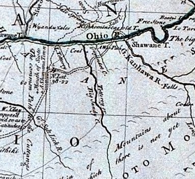
Does anybody know what map it is that names it Totero river?
June 5, 2003 at 3:34 am #7467Linda the MAP that I have is a 1755 Map by Lewis Evans
there is also a map done by mitchell, and one done by Powell.
Connelly IS CORRECT by the map that i have,If somebody got something on Connelly tell them to post it.
George
June 5, 2003 at 3:34 am #7468Hope I hear back from him. Were all three of those guys explorers?
June 5, 2003 at 3:34 am #7469Here’s Lewis’s map.
http://images.library.uiuc.edu/sid/bin/show_gif.plx?client=maps&image=XF_912.sid
It’s kind of hard to find the right portion. I found it and took a screenshot of the area we’re discussing.
https://saponitown.com/forums/wp-content/uploads/vb/images/totteroy-map.jpg
There’s an interesting bit on a site from the University of Southern Maine
http://www.usm.maine.edu/maps/exhibit10/10-01.html
On the other hand, our definition of diaspora may be readily applied to the experiences of many Native American nations. We can trace the manner in which some mid-Atlantic and Northern tribes were squeezed out by European colonists in a unique map from 1755 [3]. This map identified different categories of Native Americans: open lettering represented “Nations extinct” (e.g., the Pequots in eastern Connecticut); shaded lettering represented either the original locations of Indian nations or those nations which were “almost extinct” (e.g., the Nanticokes in Maryland); and, completely black lettering represented “Nations still considerable” (e.g., the several Iroquois nations in New York).
I’m getting cross-eyed trying to read any more of this. I was wondering if this bit about the lettering might be relevant, but I suppose this is the name of a creek or river, not a tribe per se, so I don’t know if it would apply.
June 5, 2003 at 3:34 am #7470George’s quote:
Of the Toteros we have some evidence of there tenancy on the BIG SANDY.they had a village near Hager Hill,one at Cliff,and another on Johns Creek near McCombs in Pike County John’s Creek
Brenda’s said: Meredith obtained a track of land 10 mile wide and 30 miles long on John’s Creek. I have the deed for this strip of land but it is on the old handwritting and very difficult to read. I believe it was sold to Henry Newsome…….Crystal has Newsome in her line.
-
AuthorPosts
- You must be logged in to reply to this topic.
